Mudboil Remediation Tully Valley
** The comment period for the Mudboil Scoping Document is now CLOSED **
EPA Region 2 will be accepting comments on the Scoping Document, submitted in writing, until November 30, 2010:
Maria R. Clark
Environmental Scientist
USEPA Region 2
290 Broadway, 25th floor
New York, NY 10007
clark.maria[at]epamail.epa.gov
On November 5, 2010, forty people attended a public scoping meeting led by the USEPA Regional NEPA Coordinator for Region 2. OEI assisted the Regional NEPA Coordinator’s office with meeting logistics and community notification.
At the request of USEPA Region 2, OEI is making available the following two USEPA documents, which are summaries from the November 5, 2010 public scoping meeting
Click to view:
NEPA PUBLIC SCOPING MEETING ON EPA REGION 2 SCOPING DOCUMENT – Questions and Comments
NEPA PUBLIC SCOPING MEETING ON EPA REGION 2 SCOPING DOCUMENT – Issues and Suggestions
Thanks to everyone who attended and thanks to EPA for holding the meeting.
Program Goal: Tully Valley Mud Boil Remediation is designed to improve surface water quality by limiting sediment discharge to Onondaga Creek from mud boils (muddy springs).
Activities or products:
OEI manages federal funds and holds access permits for installation and maintenance of remediation measures:
a) Diversion ditch guides tributary surface water away from mud boils.
b) Impoundment dam slows down outflow, allows heavier sediments time to settle.
c) Depressurizing wells release water pressure without added sediment.
Repeated dredging of the impoundment dam and maintaining the diversion ditch are performed by contract excavators.
OEI contracts monitoring and public education tasks to the US Geological Survey (USGS) through an intermediate contract with Onondaga County Soil and Water Conservation District (OCSWCD). Design modification of remediation measures, monitoring, and public education are conducted by USGS’s William M. Kappel (Bill Kappel), chief regional hydrogeologist, in his dual roles of technical consultant and public educator.
Public education improves understanding of the role of mud boils in water quality and the area’s complex hydrogeology. Bill Kappel provides presentations, news interviews, and fact sheets. He works to increase awareness of variation in the sources of suspended sediment in Onondaga Creek, and the several sources of hydrostatic pressure on the mud boils.
Successful Outcomes and future work needs:
USGS data show that from 1992 to the present (early 2009), remediation measures successfully reduced mud boil sediment load to Onondaga Creek from 30 tons per day to less than 1 ton per day.
Continuing monitoring indicates mud boils are continuing and may emerge directly in Onondaga Creek, bypassing the existing remediation measures. Two new (2008) pilot projects to further reduce artesian pressure at the mud boils are being monitored for their effects on the mud boils’ level of activity.
OEI Organizational Capability:
OEI provides a hub for interagency and public communications. OEI provides contract management in a multi-agency/public interface. OEI maintains many of the records on the history of mudboil remediation.
Links:
OEI – Tully Valley Mudboils: Onondaga Creek Fact Sheet
USGS (2009) – Remediation of Mudboil Discharges in the Tully Valley of Central NY
USGS (1998) – Remediation of mudboil discharges in the Tully Valley of central New York
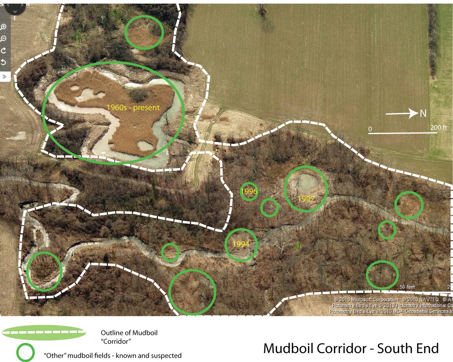
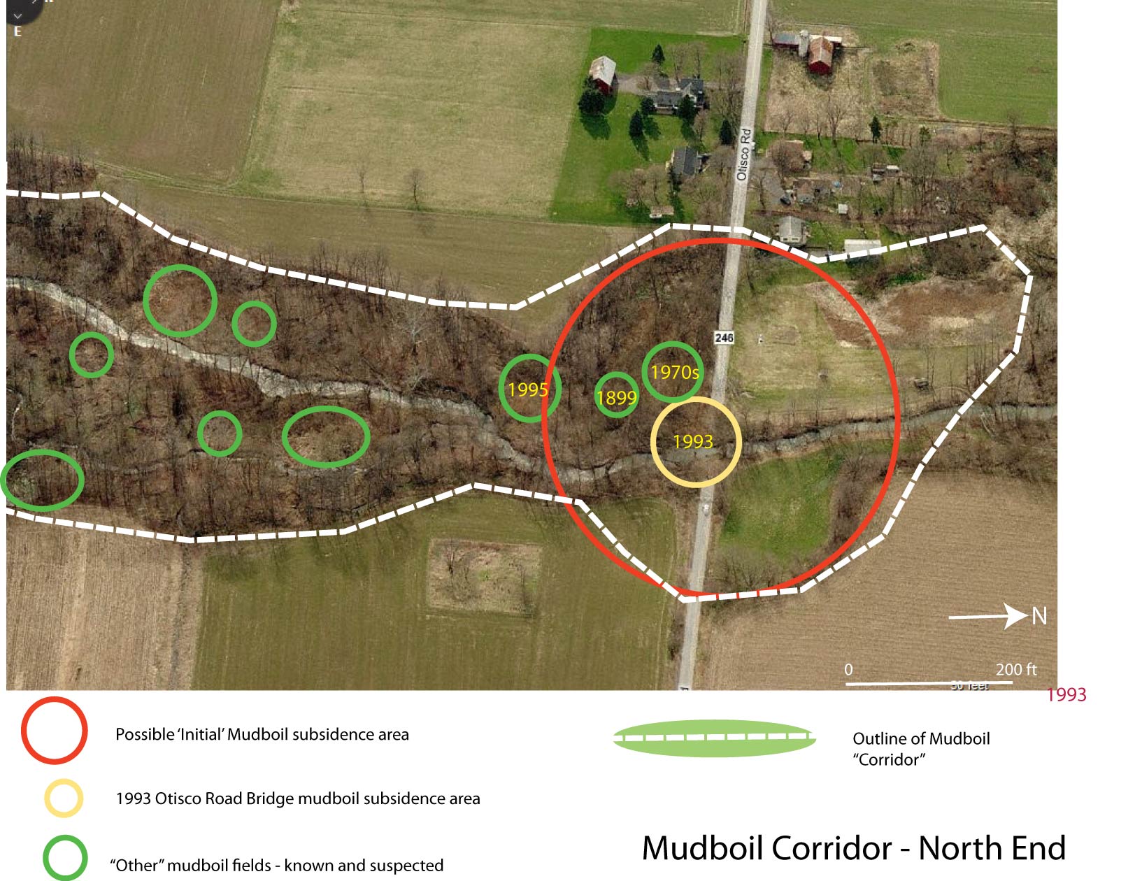
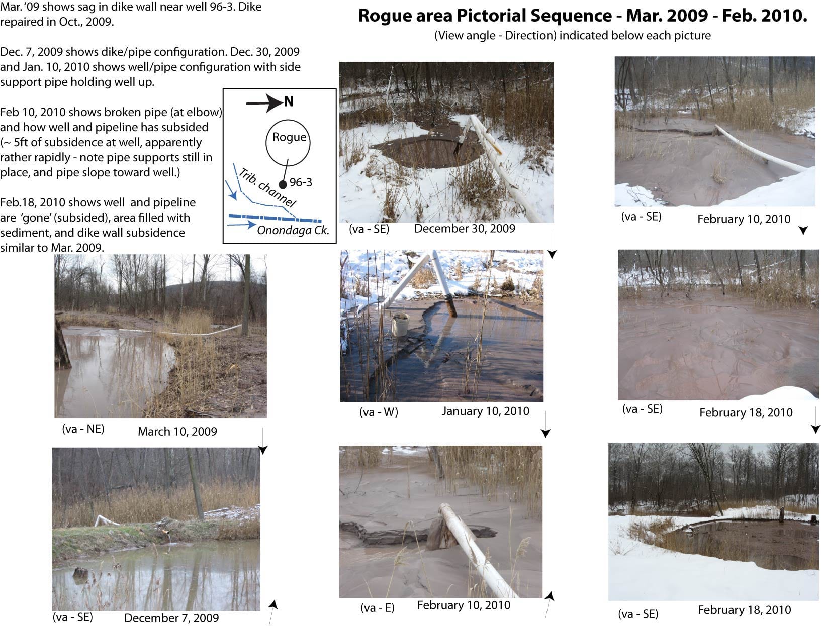
A Concise History of the Mudboils – The following documents, prepared in August 2010, are notes and accompanying images that summarize and present research conducted by William Kappel, Hydrogeologist, US Geological Survey, in support of the Onondaga Lake Partnership.
– Mudboil Activity History and Thoughts (doc)
– Rogue area sequence 2009-2010
USGS – Tree Rings Record 100 Years of Hydrologic Change Within a Wetland
Lindsay Speer (2010) – Tully Valley Mudboil Factsheet